June
2023
 Crispin Littlehales, Executive Editor
All together now
Those of you who read my Letter from the Editor religiously know that I always home in on some aspect of our industry that, hopefully, gets us all thinking. Our focus this month is sustainability.
It’s no secret that we’re in a tricky place when it comes to sustainability. We spew pollutants, particularly black carbon, every time we launch. Experts say this could affect atmospheric chemistry and heating. Satellite re-entries are also of concern since they deposit materials that are potentially hazardous to the upper atmosphere. Then there is the whole issue of space debris, and the way satellites interfere with ground based optical and radio astronomy observations. Clearly, we’re an industry dedicated to solving crucial problems, but we create others in the process.
A growing number of companies, groups, and government organizations are rallying to the call for action. Last September, the Federal Communications Commission (FCC) adopted new rules requiring satellite operators in lowEarth orbit to dispose of their satellites within five years of completing their missions. While to date there are no instructions for dealing with space debris in any space law treaty, Article IX OST (United Nations Outer Space Treaty) requires states to conduct their outer space activities “with due regard to the corresponding interests of all other States Parties.” This means that it is up to all of us here on Earth to cooperate and work together for the common good. And so, we shall. Helen Keller said it best, “Alone we can do so little; together we can do so much.”
Speaking of which, Satellite Evolution Group has for the last several months been tinkering with ways to bring us all closer together. We know you are a hard-working bunch with little time to spare. That’s why we created a new Mobile App that places industry news and commentary in the palm of your hand 24/7. Available in both Android and Apple format, our SatEvo Mobile App delivers Daily News Updates, Feature Stories, Interviews with High Level Executives, Market Analyses, and Push Notifications relating to relevant industry development. You can even access special content that’s not available on our general web platform. We’ve also created dedicated groups to enable interaction with likeminded members of the space and satellite community through a secure networking platform that is easy to use. To get on board, all you need to do is scan the QR code on page 9 of the magazine.
In this issue of Satellite Evolution Global, Jakob Kallmer, founder, and CEO of Satcube shares his thoughts on why the company’s Ku Secure terminal is such a strong contender when it comes to delivering secure internet connectivity, even under extreme conditions. We also speak with ALE’s founder and CEO, Lena Okajima to discover the origin of her company’s unique human-made shooting stars and how they will both entertain audiences and enlighten scientists. In addition, we hear from Chiara Manfletti, Director, and COO of Neuraspace, who discusses the risk mitigation and efficiencies of the orbital servicing market. Finally, Wendy Carrera, Senior Manager of Digital and European Institutions at Airbus Defense and Space shares her insights on driving sustainable and resilient agriculture with Earth Observation and Simon Partridge, Chairman of Covelya Group, takes a look at how subsea IoT is helping to chart the deepest corners of our planet.
www.satellite-evolution.com | June 2023 3 #Satcube #Neuraspace #ALE #Airbus #CovelyaGroup
Editorial
Photo courtesy Satcube
Features & Market Reports

www.satellite-evolution.com | June 2023 4 Editorial Contents DS Air Publications 1 Langhurstwood Road, Horsham, West Sussex, RH12 4QD, United Kingdom T: +44 1403 273973 | F: +44 1403 273972 | Email: admin@dsairpublications.com | www.satellite-evolution.com Satellite Evolution Global - June 2023 - Volume 2 No. 5. ISSN: 2755-1326 News & Social Media Editor Nicole Lewis nicole.lewis@dsairpublications.com Executive Editor Crispin Littlehales crispin@dsairpublications.com Managing Director David Shortland david@dsairpublications.com Publishing Director Richard Hooper richard@dsairpublications.com Publisher Jill Durfee jill.durfee@dsairpublications.com Business Development Manager Belinda Bradford belinda@dsairpublications.com Circulation Manager Elizabeth George admin@dsairpublications.com Production production@dsairpublications.com No part of this publication may be transmitted, reproduced or electronically stored without the written permission from the publisher. DS Air Publications does not give any warranty as to the content of the material appearing in the magazine, its accuracy, timeliness or fitness for any particular purpose. DS Air Publications disclaims all responsibility for any damages or losses in the use and dissemination of the information. All editorial contents Copyright © 2023 | DS Air Publications | All rights reserved Regulars Executive Q&As Satellite News & Analysis 6 Executive Movers & Shakers 32 Q&A Lena Okajima, Founder and CEO, ALE 16 Q&A Jakob Kallmer, Founder and CEO, Satcube 26 Q&A Chiara Manfletti, Director and COO, Neuraspace 28 #ALE #Neuraspace #Airbus #Satcube #SpaceportCornwall #KISPE
Discovering what lies beneath - subsea IoT helps chart the deepest corners of our planet 10 Spaceport Cornwall sets a green space launch standard 20 Driving sustainable and resilient agriculture with Earth Observation 24 Marketing Production Manager Jamaica Hamilton jamaica.hamilton@dsairpublications.com

National Physical Laboratory (NPL) joins consortium developing EO capabilities
UNITED KINGDOM: The National Physical Laboratory (NPL) has joined a national consortium who are developing new Earth Observation (EO) capabilities, including climate information which will be used to address the climate emergency in the UK.
NPL will work with partners on two projects led by the National Centre for Earth Observation (NCEO). The first project is to create a UK Earth Observation Climate Information Service (EOCIS), the second to develop a new digital infrastructure in the form of an Earth Observation (EO) DataHub (EODH).
EO data from space provides immensely valuable knowledge of the state of our environment, the impact of climate change and options for mitigating and adapting to climate change. It is challenging to transform complex datasets into trustworthy information usable by policymakers and society in general. EOCIS and EODH will create a suite of high-quality, timely climate information addressing national challenges, built on UK expertize, and linked to powerful new analysis capability.
The EOCIS is a national project funded by the UK
government through the National Environment Research Council (NERC) which will, for the first time, enable the UK to create, maintain and expand regional and global climate data from space through its own service. This trustworthy data will increase understanding of global climate-related issues ranging from melting polar ice to urban heat, and from changes in lakes and coastal waters, to landscape greenhouse gas emissions. Such information helps target mitigation and adaptation action in an effective manner. In addition to the global perspective available from EO, EOCIS will create UK-focussed data that can address local-scale issues, such as the climate risks to infrastructure.
NPL has an important role underpinning the quality of UK-focussed products. To obtain sufficient density of information for local-scale applications, observations from many satellites need to be combined. NPL will underpin the quality of these combinations by ensuring the input radiometric observations across the considered sensors are interoperable, through cross-calibration – or harmonization – to a common reference with quantified uncertainties.
Over the coming months, EOCIS will establish a service online where its climate information will be made freely available to all in a bid to advance climate science and enable better informed decisions to meet national climate targets.
In parallel, the UK is developing the EO DataHub. The goal of the EO DataHub is to develop a world leading next generation of computing architecture to better facilitate the opportunities presented by the EO sector. The hub will
www.satellite-evolution.com | June 2023 6
Satellite News & Analysis #NPL #EO #Climate
Photo courtesy NPL
be a centralised software infrastructure that will provide a new ‘single-point’ of access for EO data offerings from distributed public and commercial centres – including EOCIS data products.
Between the variety of different EO data providers and platforms today, the discovery, access, and pre-processing of “fit for purpose” data, before analysis can begin, presents a significant overhead to even EO experts. Having a ‘singlepoint’ helps to address these key challenges in EO data access and trustworthiness by providing a common standardised set of services, which the UK EO community can access and use to develop new EO services and tools.
The end-to-end quality of the data distributed by the hub will be a key differentiator between the new UK offering versus current EO services. NPL will define a product quality certification scheme for data on the hub, including cataloguing of data provenance, uncertainty and other quality metadata/metrics.
These projects together will provide the UK with readily available and integrated data sets and information that will be an invaluable and trusted resource for science, policy makers and businesses.
Dr Cyrus Larijani, Strategic BD Manager, NPL said: “NPL is recognized as leading international efforts on EO data quality and ascribing uncertainty/confidence information to it in a readily interpretable manner. NPL is delighted to working with partners on this programme and developing the tools required to support the National Space Strategy.”
Prof. Chris Merchant, lead scientist for the EOCIS at NCEO University of Reading said: “The EOCIS will enable many talented scientists all across the UK to work together, creating information needed to respond to the climate crisis. The new climate data from EOCIS will be used to better understand growing climate risks and how to respond to them. We’ll see new and better climate data from space, for the UK and the world. And we’ll see innovation around getting that information readily into the hands of people who need to use it.”
Indonesia’s SATRIA communications satellite successfully launched
SOUTHEAST ASIA: The SATRIA communications satellite was successfully launched atop a SpaceX Falcon 9 vehicle from Cape Canaveral in Florida.
SATRIA (SAteliT Republik IndonesiA) is a satellite designed to bridge the digital divide in Indonesia. Offering throughput of 150 Gbps, it will deliver high-speed Internet to the thousands of islands in the Indonesian archipelago, providing connectivity across thousands of zones for schools, hospitals, and public buildings, as well as regional government facilities not already connected by existing terrestrial or satellite systems.
Thales Alenia Space was chosen to build the satellite by the Satelit Nusantara Tiga (SNT) consortium on behalf of the Indonesian Ministry of Communications and Information Technology (Kominfo). This very-highthroughput satellite (VHTS) is based on Thales Alenia Space’s all-electric Spacebus NEO platform and features
a fifth-generation digital processor. The company also supplied two satellite control centers — main and backup — and the mission ground segment for the all-digital payload. In addition, Thales Alenia Space has set up a complete training program for SNT engineers, some of whom have joined the project team at the company’s facilities in Cannes and Toulouse for the duration of the program.
SATRIA will be the first VHTS communications satellite in Indonesia, and also the most powerful in the South-East Asia region. With a launch mass of 4,6 tons, it will operate in Ka-band and be positioned in orbit at 146° E for a design life of 15 years.

“I am delighted to see SATRIA successfully launched. This mission will deploy very-high-throughput Internet across Indonesia and help to develop the nation’s digital infrastructures,” said Marc-Henri Serre, Thales Alenia Space Executive Vice President, Telecommunications. “After the construction of the Palapa-D and Telkom-3S satellites, the Telkom 3 payload, and the future Telkom 113 satellite, SATRIA confirms our successful partnership with Indonesian operators.”
IEC Telecom unveils a new maritime
LEO-based solution in the Philippines
SOUTHEAST ASIA: With high-speed, low latency, reliable and cost-effective connectivity, low earth orbit satellites are transforming maritime communications and the Asia Pacific region is set to benefit, says satcom specialist IEC Telecom.
IEC Telecom has been showcasing the benefits of LEO connectivity to the Philippine maritime sector at the PhilMarine show. PhilMarine gathered key national stakeholders and international specialists to exchange ideas, develop partnerships and draw a roadmap towards achieving the nation’s 2028 transport vision, the Maritime Industry Development Plan (MIDP).
Nabil Ben Soussia, Group COO of IEC Telecom, commented: “The MIDP has an ambitious agenda, and to meet its targets will require new policies and regulations, as well as significant technological advancement. Satellite telecommunication has a key role to play here in enabling this development.
“At this fast-moving time it’s important to remember
www.satellite-evolution.com | June 2023 7 Satellite News & Analysis
Photo courtesy Thales Alenia Space/Imag[IN]
that maritime digitalization’s success depends on carefully considered implementation. Satcom on board is not only about the hardware or network coverage; it’s about a connectivity system that remains operational at all times, enabling business continuity and reliable crew welfare,” he said.
As the world’s leading supplier of ships’ crew, The Philippines is at the heart of the maritime world and keen to embrace the many opportunities offered by the rapidly growing LEO sector. For the crew, this revolution signals opportunities such as faster access to the internet, realtime communication with home, workplace support, and comprehensive e-learning programmes.
While digitalization is the key to future changes, crews are the change-makers. As new generations join the workforce, access to connectivity has become a ‘must have’ factor. In fact, according to a recent survey by Dell (TrueList, 2023), technology is a deciding factor in as many as 91 percent of Gen Z job decisions, highlighting satcom’s key role in talent attraction and retention.
Recognising these trends, IEC Telecom has been in the Philippines to present its latest LEO/GEO hybrid solution: Xpand Maritime. Powered by Starlink, Xpand supports heavy-consuming business and welfare applications.
Should the prime link go down, the system will be automatically switched to an L-band network with a set of optimized applications, supporting digital operations in a low bandwidth environment both for critical operations and crew communication.
Xpand comes with advanced information communication and technology (ICT) toolkit, including remote network management, a crew voucher system, and a wide range of value-added services. The whole set-up can be tested, updated or upgraded seamlessly while the vessel continues its course. By optimizing the operational cycle onboard, Xpand helps to decrease costs and reduce the vessel’s carbon footprint.
Importantly, Xpand also offers many cyber-security add-ons, from basic cyber shields to fully encrypted communication channels, making it invaluable for special operations at sea too.
“We are delighted to unveil the Xpand portfolio to the Philippines and Asia-Pacific region,” said Mr Ben Soussia. “This smart solution has been designed to harness the benefits of LEO connectivity. These are exciting times for satellite communications and we’re looking forward to working with many sectors of the maritime community to help them progress their digital journey.”
www.satellite-evolution.com | June 2023 8 Satellite News & Analysis #IECTelecom #LEO #GEO #Maritime
Photo courtesy of IEC Telecom
Satellite Evolution Group launches Branded Mobile App


GLOBAL: Satellite Evolution Group has for the last several months been tinkering with ways to bring us all closer together and we know you are a hard-working bunch with little time to spare. That’s precisely why we created a new Mobile App that places industry news and commentary in the palm of your hand 24/7.
Available in both Android and Apple format, our SatEvo Mobile App delivers Daily News Updates, Feature Stories, Interviews with High Level Executives, Market Analysis, and Push Notifications relating to relevant industry developments. You can even access special content that’s not available on our general web platform. We’ve also created dedicated groups to enable interaction with likeminded members of the space and satellite community through a secure networking platform that is easy to use.
Richard Hooper, Publishing Director said: “Statistics show that the average adult spends on average more than three hours per day on their mobile device, and satellite industry professionals are no different. Our new Mobile App will deliver Daily News Updates, Dedicated Features/ Q&As, Market Reports and Push Notifications relating to relevant industry news and events. Via Push Notifications we are getting closer to a direct interaction with our loyal
readership and audience, and will be able to deliver industry updates and news in a split second.”
To get on board, all you need to do is scan the QR code or click the links!
AsiaSat acquires Lightning International - expands service to provide additional content distribution
EASTERN ASIA: Asia Satellite Telecommunications Co has announced its 100 percent acquisition of Lightning International Limited. The addition of Lightning into the AsiaSat family is a strategic move to expand the company’s services and extend its clients’ reach to global audiences through traditional and new distribution platforms including OTT and FAST.
“I am excited to announce this investment in Lightning in order to strengthen AsiaSat’s capabilities in channel distribution and provide customers with end-to-end B2B and B2C media solutions,” said Roger Tong, Chief Executive Officer of AsiaSat. “We welcome the experienced and talented team from Lightning joining us, and integrating their expertize and business connections as part of our transformation efforts.”
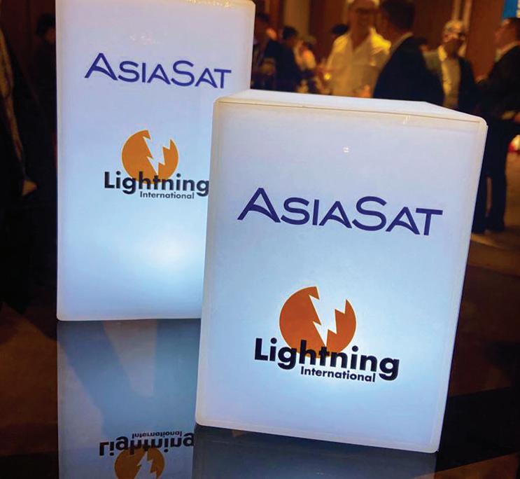
With over 12 years of distributing TV channels and programme content to worldwide audiences via TV stations, pay TV operators and streaming platforms, Lightning represents producers, channels and other media businesses from Europe, Asia and around the world, and provides advice on a wide range of content and media solutions. Combining Lightning’s expertize in content distribution with AsiaSat's all-embracing satellite and IPbased distribution capabilities will enable both companies to deliver customised solutions including content aggregation and playout, channel distribution and affiliate management.
“We are thrilled to join forces with AsiaSat and bring our experience in TV content distribution and solutions into the company,” said James Ross, Founder & Chief Executive Officer of Lightning. “We believe our combined strengths will enable us to grow stronger together, through the synergies between us.”
www.satellite-evolution.com | June 2023 9 Satellite News & Analysis
Phone image courtesy Farknot Architect/Shutterstock
Photo courtesy AsiaSat
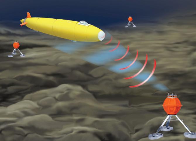
Discovering what lies beneath - subsea IoT helps chart the deepest corners of our planet
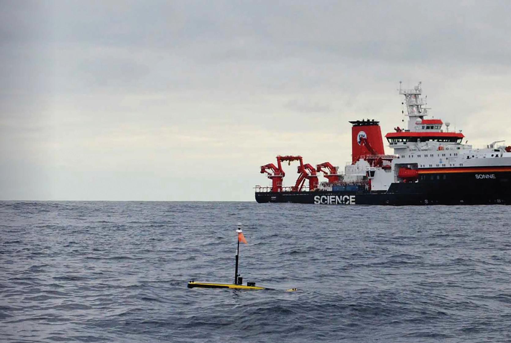
As technology advances, so too does the way we explore our world. With our ocean floors far less explored than the surface of Mars, advancements in technology are now allowing us to conduct IoT-fueled research and exploration in ways that heretofore have not been possible. With advances in acoustic and optical communications, edge computing, artificial intelligence, environment-monitoring satellites, and underwater drones, new capabilities have become available. Drawing on recent innovations, we must outline the art of the possible and why communicating underwater is at the heart of everything.
Our oceans cover 70 percent of planet Earth though we’ve observed less of their depths than we have the surfaces of Mars or the Moon. While the atmosphere on the Moon may be survivable in a spacesuit for some months, the depths of the oceans are survivable for no more than a few hours and only then in the strongest of machines. With as much as 11km of water above, only a
handful of humans have ever ventured there.
Our oceans feed millions and critically moderate the atmosphere which means they hold the key to climate change. Understanding them on a finer spatial and temporal scale is therefore critical to the Earth’s future. Analyzing oceans from the surface, however, be it by satellite, air or surface ship, only gets us so far. To really understand what is happening deep down, we need to get closer.
THE CHALLENGES OF DEEP-WATER EXPLORATION
To gain a better and more detailed understanding of the world underwater, we need to gather so much more data from the depths. This includes a range of physical, chemical and biological factors, such as currents, sediment load, salinity, fluorescence, nitrogen, temperature and biomass, bacterial load etc. But, with the inhospitable and dangerous environment of deep-water making it largely a human no-go zone, ambitions to garner further information have so far proved challenging. It is for this reason that science has turned to the innovative technology of drones — specifically automated underwater vehicles — to carry out the task.
Until recently, the issue with automated underwater vehicles was that developments in their batteries were slow; communications and navigation unreliable; and autonomy limited. However, recent advances from computing power have significantly reduced battery energy consumption. This means that the same batteries now last a great deal longer, allowing for more processing power, and therefore can be used to conduct more in-situ analysis.


FIXED INSTRUMENT APPLICATIONS
Fixed instrumentation enables ocean analysts to collect data and with reliable acoustics communications, have it communicated back to the surface in real-time. When put into application, these advancements have brought about huge tangible benefits for humanity. After the catastrophic tsunami hit Indonesia in 2004, Sonardyne, one of the Covelya Group companies, got to work on modifying existing underwater surveying products to provide satellite-based early tsunami warnings.
www.satellite-evolution.com | June 2023 10
Simon Partridge, Chairman of Covelya Group
#Subsea #IoT #Acoustic
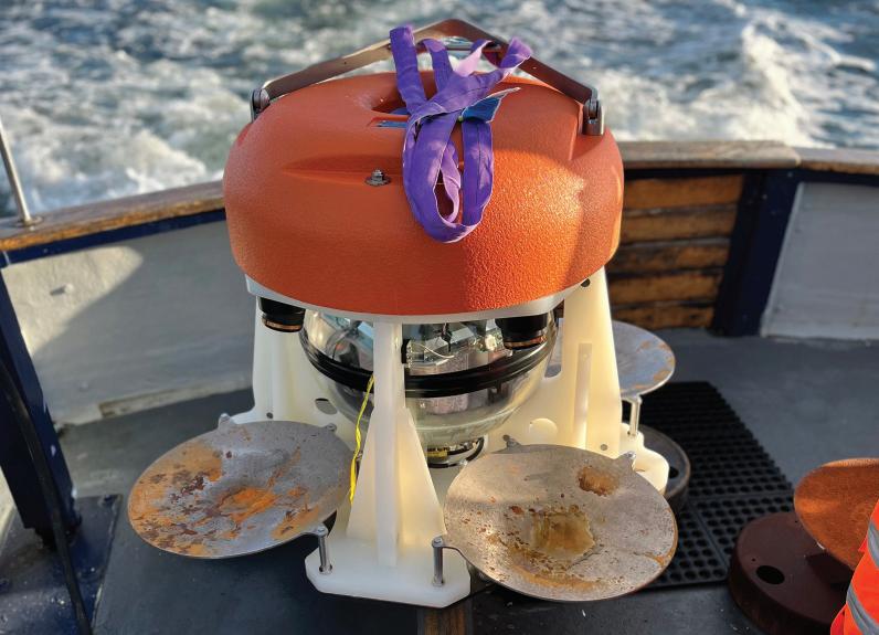
Sonardyne Origin 65 ADCP. Photo courtesy Sonardyne
Simon Partridge, Chairman of Covelya Group

triggers the device to send a message to a surface buoy using water acoustic communication. In turn, this data is relayed via satellite to a control room on land from which warnings can be sent to coastal communities advising people to take critical precautions.
Another application example of where fixed instruments are being used is to help better understand how tectonic plates move relative to each other underwater, which could ultimately help predict major earthquakes. Monitoring their movement over time requires phenomenal precision, as shifts may only be a few centimeters over many years.

MOBILE APPLICATIONS
Similar devices using the same techniques are being deployed to measure factors relating to climate change, such as carbon sequestration. Chelsea Technologies STAFF (Single Turnover Active Fluorometry) measures phytoplankton (tiny plants) photosynthesis in the ocean, which are at the very start of undersea life cycles.
Other Covelya Group companies, EIVA and Voyis, provide software and equipment for subsea surveys and underwater archaeology projects. Recently, Sir Ernest Shackleton’s ship, Endurance, was found by a semi-

www.satellite-evolution.com | June 2023 12
Sonardyne optical coms Bluecomm 200 on Triton sub.
Subsea IoT
Photo courtesy Sonardyne
The tsunami warning seabed device can sit 2.5km below the water’s surface, where it continuously analyzes any minute changes to pressure. Any event it detects
Optical & acoustics telemetry from seabed nodes to AUVs.
Photo courtesy Covelya Group
autonomous underwater vehicle in very deep Antarctica waters. The imagery and 3D models acquired from highresolution imaging technology are incredible.
ADVANCEMENTS IN TECHNOLOGY
Due to the properties of seawater, acoustic communications — although it has advanced much over the years — it is still somewhat limited in its bandwidth to something not dissimilar to dial-up internet from the 1990s (~50kbits/sec). But several factors are helping to improve this limitation.
Optical free space communications through water are starting to change the way things can be done. Optical communications run at the speed of light, (299,792,458 meters/sec). However, as light does not reach far through the ocean, the speed of connection in practice is limited to 200Mbits/s over a few hundred meters at best, but as fast as 1GB/sec at a distance of around six meters.
Thanks to this improvement, subsea devices can now record vast quantities of sensor data, with acoustic communications providing over-the-horizon control and transfer of small quantities of the data in near real-time. The next step, which Sonardyne is now working on, is the deployment of subsea devices for many years at a time which use optical communications to offload gigabytes of data to autonomous underwater drones as they maneuver into proximity using laser optics.
Another factor of technological advancement is edge computing, which allows data to be processed where it is generated, enabled by advances from mobile phones and image-processing chips. We now have the capabilities to
provide subsea devices with spare computing capacity. Edge computing can then be used to analyze large quantities of data in-situ and provide pertinent summaries which are small enough to transit by lower bandwidth acoustic communications. Through edge computing, Sonardyne’s new series of acoustic doppler current profilers allow users to write their own routines and algorithms to process subsea data, download it remotely via acoustics, and command it to offload only the critical information to a surface gateway.
THE FUTURE OF UNDERWATER DISCOVERIES
To predict what is next in deep sea technology is always difficult, but there is no doubt we will soon be seeing an increase in interconnectedness, such as that required by swarms of drones, which all need to share data, navigate, and communicate with one another. We may also see further improvements in energy consumption and battery life. Further progression in edge computing will almost certainly be on the horizon as well.
The need and desire to discover what is happening deep down in the ocean remains critical to our survival and evolution.
While human exploration is fraught with dangers and challenges, emerging technology is rapidly changing the way scientists can study the ocean. Remote distributed sensing, processing, communications, satellites, underwater drones, and mobile as well as static seabed devices are all giving us an opportunity — sometimes for the first time — to look up close and personal at what really lies beneath.
www.satellite-evolution.com | June 2023 14
Techonic plate monitoring Waveglider USV collecting data from nodes in 3km water depth off Chile. Photo courtesy Liquid Robotics
ALE creates “shooting stars” for both scientific research and entertainment
Space technology company ALE (Astrolab Experience) is planning to light up the night sky with spectacular displays of its own proprietary shooting stars while accumulating atmospheric data from the mesosphere. On the science side, the company expects to contribute to the creation of accurate weather models that can help to address climate change. As for entertainment, ALE envisions the use of its human-made meteor showers to enhance large-scale events and inspire audiences to embrace space. We sat down with ALE’s founder and CEO, Lena Okajima, to find out more about this unique endeavor.

Crispin Littlehales, Executive Editor, Satellite Evolution Group
Question: What prompted you to establish ALE?
Lena Okajima: I have a PhD in Astronomy from the University of Tokyo. One night, while still a student, I saw the Leonids meteor showers and that inspired me. I chatted with one of my colleagues about the idea of recreating this phenomenon by releasing very tiny particles using a microsatellite. I was motivated to move forward with this idea because I believe fundamental science leads to innovation. I wanted to find a way to balance business with science and I came up with the idea of using man-made shooting stars to create an entertainment spectacle while utilizing the information derived from measuring the trajectory of the shooting stars to advance our scientific understanding of the mesosphere.

www.satellite-evolution.com | June 2023 16 Q&A Astrolab Experience
Q&A
Lena Okajima, Founder and CEO, ALE
Satellite Evolution Global
SKY CANVAS - ALE's state-of-the-art vacuum chamber enables tests and experiments in environments closely resembling outer space. Photo courtesy ALE

Question: How many satellites do you currently have and where do they orbit?
Lena Okajima: We launched two satellites but one failed to orbit and burned up in the atmosphere. Now we have only one satellite which is in a sun synchronized orbit about 400 kilometers above the Earth going from the North Pole to the South Pole. We are in the process of building the third satellite which we expect to launch in 2024. We will realize our first public SKY CANVAS event, with its wonderful meteor showers, in 2025.

Question: Why did you choose to investigate the mesosphere?
Lena Okajima: Natural shooting stars occur in the mesosphere which is the layer of the Earth’s atmosphere between the stratosphere and the thermosphere extending from about 50 kilometers to 85 kilometers above the Earth. In addition to being intrinsic to the production of ozone, the mesosphere is responsible for the planet’s atmospheric tides.
By observing our shooting stars’ trajectory data, we can collect new information relating to the mesosphere including wind speed and atmospheric composition. This is very important for understanding climate change. Thus far, collecting data about the mesosphere has been challenging. This is because the mesosphere is too high for airplanes and balloons to gather accurate information and it is too low for satellite observations. Since we know the size and composition of the particles used in
our shooting stars as well as the velocity, our orbits and emissions have the potential to provide valuable insights that will enrich our understanding of weather and climate behavior. Our research will also enable scientists to better understand the asteroid belt since many natural meteor showers originate there. The more we know about shooting stars, the more we know about the asteroid belt.
We believe we can improve the accuracy of existing models by adding the data we collect from our shooting stars. Right now, the data is limited, and we need to accumulate much more. Once we progress further, we plan to give the scientific community free access to our data, but, as I mentioned, we are in the early stages.
Question: ALE has two very different areas of focus. We’ve talked about what you are doing on the science side, how about the entertainment side—SKY CANVAS— what are you hoping to achieve?
Lena Okajima: Humanity has been mesmerized by the night sky since the dawn of time. Our shooting stars can be viewed by the naked eye over a wide area of 200 kilometers in diameter. Being able to see one of the most elusive and magical phenomena in our universe and to share that with a huge crowd of people first-hand at the same time has not been previously possible.
The Apollo project, the Artemis project, the ISS, and all the other space missions are distributed via broadcasting. They can be witnessed on a screen which is exciting but that is very different from looking up into the
www.satellite-evolution.com | June 2023 18
ALE founder, Lena Okajima with an engineering model of the new ALE-3 satellite. Photo courtesy ALE
#Orbit #SKYCANVAS #ShootingStars Q&A Astrolab Experience
night sky and viewing space in an entertaining way. I want many people to be interested, even inspired by space and science. The entertainment that is offered by SKY CANVAS will function as a catalyst for that. What is more, our approach to entertainment is sustainable. There is no debris and no noise.

Question: Can you elaborate on ALE’s core values; why did you choose these values and how are they informing the company’s evolution?
Lena Okajima: To me, core values are key to uniting people, whether that’s team members or partners. We developed our core values as a result of interviewing our employees about five years ago. I asked everyone the same question: “Why did you choose to work here?” Many people gave me a similar answer, and these became our core values which are curiosity, pathfinder, and evolution. We define these as:
• Curiosity is the fundamental attitude towards exploring the unknown and it is the emotion and root of intellectual activities such as self-initiated investigation, learning, and studying the nature of things: it is the origin of all activity.
•Pathfinder is the initial process of penetrating unknown areas to develop social infrastructure and form societies, towns, and cities: it Is an activity to transform curiosity into a value proposition together with likeminded people.
•Evolution is the phenomenon in which the characteristics of an individual species change over the course of generations: ALE positions evolution as the activity of transforming changes brought about by Pathfinder into a sustainable routine.
Each member of our team embraces these values which makes it possible for us to move forward and accomplish these things that have not yet been done before.
Question: Do you see SKY CANVAS as a way of inspiring young students to participate in STEM?
Lena Okajima: I believe our efforts will stimulate students’ interest in STEM areas and we intend to create programs to encourage that. We are already discussing ways for children to observe our shooting stars both for education and inspiration.
Question: Where do you see the company headed in the next 1-5 years?
Lena Okajima: The next SKY CANVAS satellite, ALE-3, will launch next year and the first commercial service will be available in 2025. This is a significant milestone. While continuously conducting our meteor shower shooting stars events, we will be gathering atmospheric data and improving the accuracy of our models.
At first, our fundraising will come from the entertainment side. We don’t expect to have a profit from the data services in those first few years but once we accumulate data from our satellite and create more accurate data models, we can consider selling our data services.
We are collaborating with RIKEN Center for Computational Science (R-CCS) which developed Fugaku, the most powerful supercomputer in the world.
We see ourselves at the forefront of space entertainment which we believe will be a multi-billion dollar industry. We are monetizing SKY CANVAS by targeting governments that wish to bolster tourism and we are also getting inquiries about SKY CANVAS as a luxury brand. One individual contacted us because he wants to celebrate his daughter’s seventeenth birthday by showering her with shooting stars.
Our events will be huge ceremonies where many people of all ages can gather at once and share in the excitement. That said, I am an astronomer with a strong passion to contribute to science. I consider that to be the most important thing our company has to offer to current and future generations.
www.satellite-evolution.com | June 2023 19
SKY CANVAS - artists impression over New York skyline. Photo courtesy ALE
Spaceport Cornwall sets a green space launch standard
Following a launch failure in January, Spaceport Cornwall continues conversations with space businesses and launch developers. As a rather outspoken proponent of the environmental impact and potential of the space industry, they’ve set a strong standard which they hope to normalize more widely. Drawing upon the wisdom of a longtime collaborator at Spaceport Cornwall, KISPE’s Dr. John Paffett, we explore the power of green technologies in the space market, and how they can stay competitive.
Laurence Russell, Associate Editor, Satellite Evolution Group
On the outset of this year on January 9th, Virgin Orbit’s Cosmic Girl launch at Spaceport Cornwall failed after a rocket anomaly – later in April identified to be a dislodged filter in the fuel tank outlet entering the Newton-4 engine – dashing hopes for the first successful space launch from the British Isles.
While an undeniable setback, Spaceport Cornwall is keen to reprove itself. “Virgin Orbit wasn’t the only group we’ve been working with,” explains Dr. John Paffett Founder and Managing Director – KISPE, a close partner of the spaceport. “We’re still speaking to multiple developers at several stages of their businesses, including
with Sierra Space about a return craft mission opportunity in 2027/28.”
RETURNING TO FORM
Spaceport Cornwall can be argued to be the UK’s first spaceport, given that it was the first to begin construction in 2008, and how it beat Saxavord to serving a space launch mission despite the claim that Lockheed would launch in 2022.

From the derelict site of RAF St. Morgan, Spaceport Cornwall looked to serve the rising launch demand of the North Atlantic. “Launch is a supplier’s market,” explains Paffett. “Spaceports in the UK are about providing competitive, sovereign launch capability that sidesteps the cost, delay, and carbon footprint associated with shipping your payload and staff across the world.
“As a horizontal site run out of an existing airport, we had fewer costs than vertical-launch spaceports, so we had an agile business with an existing set of infrastructures and supply chains. Horizontal launch also places us well to support the future spaceplane market as with Sierra Space’s Dream Chaser.”
Spaceport Cornwall has been a landmark advocate for a greener UK space sector for years now, seemingly influencing its sister spaceports and a number of space companies around them, who have recently become more vocal about their environmental potential.
KEEPING GREEN SPACE LAUNCH ALIVE
In July of 2022, the spaceport released a carbon impact assessment courtesy of a consultation from the University of Exeter covering launch emissions with consideration to the extended carbon impact of the spaceport’s associated supply chain. While entirely expected of Cornwall, the simple application of a pollution study is leaps and bounds
www.satellite-evolution.com | June 2023 20
Cornwall Airport Newquay Runway
Green Space Launch Standard
ahead of the level of the general standard of environmental responsibility that spaceports get away with. It can be easy to forget just how uncommon Spaceport Cornwall’s environmental accountability is.

“We’re very keen to understand these impacts in order to limit them by realising the changes we can make today, as well as having conversations with our partners about what we can do in the future, Paffett states. We’ve been trying to promote the use of greener, more sustainable propellants instead of the carcinogenic, toxic systems we’ve seen in the past, as well as an environmental tariff for launchers that would go up or down depending on their launch footprint. The funds from that tariff in turn were to go to sustainable projects such as the development of Kernow Sat 1, a Cornish environmental monitoring satellite designed to monitor the health of coastal areas, sea pollution, kelp forestry, and observe rising sea levels.
“The important thing is maintaining a holistic approach. We also install PVAs for local microgeneration, use charge points for electric vehicles on site, promote biodiversity in the surrounding grounds, fund environmental research, and explore innovative carbon offsetting measures, such as the nurturing of coastal seagrass and kelp forests for carbon sequestration and research into future biofuels.”
By themselves, any one of these measures would be a novelty at best, and greenwashing at worst. One doesn’t have to look far to recognise how some polluters rely on threadbare offsetting schemes to avoid the consequences of their business’s actions. But when these measures are executed together, we can see how compounding benefits start to pioneer a playbook for the implementation of a comprehensive solution.
“Ten years ago, the idea of recovering a first-stage
rocket would’ve been ludicrous. Nowadays launch asset reuse has been proven. If we take efficiencies like these seriously, who knows what incredible things we could be doing ten years on? Through calculated offsets and new technologies, it might be possible to have a net-zero spaceport by 2030,” notes Paffett.
www.satellite-evolution.com | June 2023 21
Photo courtesy Spaceport Cornwall
COMPETING ABROAD TO DEMONSTRATE A BETTER STANDARD
As climate regulation becomes stricter and the business case for green solutions solidifies, we are steadily approaching an inflexion point whereby environmental sustainability will become synonymous with business sustainability, and businesses will be eager to snap up every green opportunity they can.
“It’s obvious that environmental assurances have an impact on customers’ perceptions,” Paffett agrees. As the launch market diversifies and sustainability becomes a must, that’ll only become truer.”
Of course, spaceports border on a uniquely relevant form of environmentalism in orbital sustainability. While incredibly vast and inhospitable, our planet’s orbital heavens are just as capable of being polluted as our lands and seas. The irresponsible proliferation of debris has the capacity to end humanity’s dreams of exploring the stars by rendering launch impossible through a layer of derelict satellites and debris shrapnel spinning about us at five miles a second.
Paffett observes, “As on Earth, a company taking measures to ensure orbital sustainability is really investing

in risk mitigation. Awareness helps us recognise the nature of the problem, but explicit regulation is more complex.
“The trick is working out how to promote innovation without stifling growth. Over-regulation isn’t a tough-love solution, it’s a message to potential partners that they’ll have an easier time of it elsewhere, potentially in countries with terrible track records for sustainability. In a competitive market, we need to walk this line to attract business, so we have the power to encourage future-proof practice.”
As with all such things, the best tactic will likely be to apply both the carrot and the stick. Paffett suggests that incentivizing developers by accelerating their licensing process if they can prove they have a solid deorbit plan for their satellites, or a zero debris method of staged rocket separations, are realistic ways of influencing a better standard.
“Ultimately, our aspirations for a greener space industry goes beyond the UK,” Paffett concludes. “Our goal has been to try to encourage everyone to think more critically about sustainability in space. While we continue to champion this standard, we’ll only come to see more and more players adopt it both at home and abroad.”
www.satellite-evolution.com | June 2023 22
Sierra Space's Dream Chaser Spaceplane. Photo courtesy Sierra Space
#Spaceport #Launch
Green Space Launch Standard
#Space #Sustainability
Driving sustainable and resilient agriculture with Earth Observation
Between geopolitical tensions threatening food supply and environmental issues, agricultural efficiency has been a particular priority for global governments. With the incredible foresight of satellite imagery, we can observe our planet’s surface and make up-to-the-minute conclusions about how best to protect it and help it thrive.
Wendy Carrera, Senior Manager of Digital & European Institutions at Airbus Defense and Space
As the world’s population grows, enhancing the efficiency and resilience of farming becomes increasingly important to our food security. Driven by global warming, the recent increase in extreme weather events (like flooding and drought) has put this under greater threat. And it’s been further compounded by Russia’s invasion of Ukraine – formerly one of the world’s largest grain producers.
While essential to the survival of the human species, agriculture can also be a driver of environmental degradation and deforestation, like in the Amazon, the Congolese, and Indonesian rainforests.
Increasingly, Earth observation is playing a crucial role in helping governments and private companies drive sustainable, resilient, and efficient agriculture by regularly capturing and delivering high-resolution imagery. Today’s commercial satellites can generate detailed images with up to 30cm resolution. What’s more, they boast extremely accurate geolocation – up to 3.5 meters to be precise. Thanks to this, anything spotted on an image can easily be mapped to a corresponding set of coordinates.
MONITORING CROPS TO ENSURE FOOD SECURITY
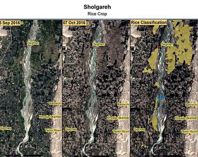
In areas of the world where food insecurity is an issue and most farming is done by small-scale producers, satellites can play a crucial role in monitoring domestic food production. The UN’s Food and Agriculture Organization’s (FAO) work in Afghanistan is a prime example of this.
Given the increasing desertification of the country, it’s crucial for an organization like the FAO to monitor irrigated crops like rice, so it can anticipate any shortages. Doing this on the ground is difficult, if not impossible, due to Afghanistan’s remote landscapes, unstable security situation, and small, scattered farming communities.
To solve this problem, the FAO turned to the Pléiades and SPOT satellites (as well as time series based on Sentinel 1, Sentinel 2 and Landsat 8) to gather imagery over seven provinces at key dates throughout the rice growth cycle. Based on these images, it was able to successfully estimate Afghanistan’s rice crop, with an error margin of less than 10 percent.
DEMOCRATIZING PRECISION AGRICULTURE
As well as simply monitoring crops, Earth observation can also be used to generate data and insights to help farmers optimize crop yields. As the world’s seventh largest agricultural yielder, the government of Türkiye attempted to do this at scale with an unprecedented monitoring program accessible to all the country’s agriculture stakeholders.
This unique programme, named TARBIL, gathers accurate, up-to-date, and comprehensive satellite imagery from SPOT 6/7 satellites across all production areas during the growing season. Satellite imagery is used in conjunction with ground information, collected by 15,000 sensors spread across the entire country.
www.satellite-evolution.com | June 2023 24
Wendy Carrera, Senior Manager of Digital & European Institutions at Airbus Defense and Space
Satellite images collected before and after harvest in order to delineate parcels and establish homogeneous areas. Image courtesy Airbus
#Airbus #Agriculture #Satellite
Once images are collected, they’re ingested into a cloud-based platform for conversion into solid vegetation maps. Additionally, object-based classification is performed over the data to create level crop type maps and generate cultivated area statistics. These are continuously uploaded to the cloud, where farmers can access them to optimize pesticide, water, and fertilizer use – as well as enabling them to spot problems early. At the same time, the Turkish government can access data to monitor environmental protection, anticipate food shortages, forecast yields, and more.

PREVENTING DEFORESTATION CAUSED BY AGRICULTURE
Multinational conglomerates in the fashion and FCMG sectors dominate much of global agriculture. Thanks to growing demand for crops like palm oil, cocoa, coffee,
cotton, pulp and paper, the same companies are also indirectly responsible for a significant proportion of deforestation.
Most of these crops are sourced from third party suppliers, rather than grown by the conglomerates themselves. As such, it’s been historically difficult for companies to achieve full supply chain transparency and monitor their true environmental impact.
Again, Earth observation can play a crucial role in changing this, with the help of services like Starling, an endto-end digital platform that monitors deforestation. Created by Airbus and global non-profit Earthworm, the Starling online portal combines satellite-derived imagery of forest cover with supply chain data from users. Using both these data sources in tandem, companies can spot deforestation early and engage with suppliers to address the problem, or switch to a more sustainable alternative.
The Starling platform also is frequently used by government entities, like the Ivorian government’s forestry agency, SODEFOR. Thanks to the platform, SODEFOR can better address the pernicious issue of cocoa-driven deforestation. Since farmers initially only clear the forest floor to plant cocoa, with larger trees being felled once crops grow taller, it’s very difficult for authorities to spot this problem early – as it’s literally hidden beneath the tree line.
By using Starling, SODEFOR was able to quickly spot newly planted cocoa and put a stop to deforestation before it happened. How? Starling’s breakthrough technology (based on satellite imagery) can spot forest disturbance below the canopy level – rather than simply at the tree line. As a result, deforestation has decreased by around 60 percent in the Ivory Coast’s Cavally Forest.
Looking forward, Earth observation can play a crucial role in feeding our growing population in a way that also protects our environment.
Success will hinge on public-private sector collaboration, ensuring all stakeholders feel empowered to work with satellite-derived imagery.

www.satellite-evolution.com | June 2023 25
NDVI maps (Normalised Difference Vegetation Index), derived from satellite imagery showing the vegetation variability. Image courtesy Airbus
#Crops #Deforestation #SODEFOR Earth Observation
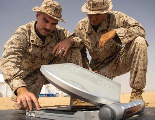
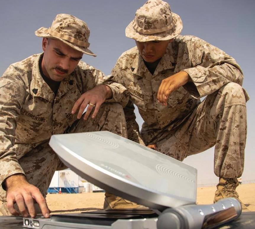
Satcube’s transportable terminals deliver secure internet connectivity
Satcube’s portable terminals are only slightly larger than a laptop, yet they can deliver instantaneous internet connectivity from just about anywhere on Earth. These battery-powered systems are rugged enough to withstand the rigors of disaster areas and war zones. That’s one reason why Satcube has already accumulated a long list of impressive customers including the U.N., the International Red Cross, and CBS News. We caught up with the company’s founder and CEO, Jakob Kallmer, who shared his thoughts on why Satcube’s Ku Secure terminal is such a strong contender.

Crispin Littlehales, Executive Editor, Satellite Evolution Global
Question: When was Satcube founded and how has the technology evolved?
Jakob Kallmer: Satcube was founded in 2006. Until 2014, we were consultants. We helped several companies in the SATCOM industry with technical innovation, product development, and prototype manufacturing of advanced pilot series. In 2015, we decided to become our own product company and in 2017, we launched our very first product. During 2018, sales increased, and we decided to invest in our own factory located in Karlstad, Sweden.

www.satellite-evolution.com | June 2023 26 Q&A Satcube
Q&A
Jakob Kallmer, Founder and CEO, Satcube
Satellite Evolution Global
Satcube Ku terminal in action with military communications
From the start, our focus has been on the Size, Weight, and Power (SWaP) factor. We created highly efficient antennas that can be packaged into ultra-portable cases powered by batteries. We also saw ease of use as a key element with the goal of enabling a non-technical person to establish a communication link over satellite in under two minutes. In addition, we made sure that the system was robust because we knew our target users would need to rely on critical communications working in the field without fail.

Satcube has invested tens of thousands of hours developing and optimizing against the above requirements and spent many more thousands of hours making the product reliable and stable with a high Mean Time Between Failures (MTBF).
Question: How is the Satcube Ku 950 different from other satellite antennas in the marketplace?
Jakob Kallmer: Satcube Ku 950 which we have named Satcube Ku Secure , meets the most rigorous demands for tactical terminals delivering mobility and security, and always-on broadband capabilities into highly compact form factors that support data, voice, and video connectivity in highly mobile military and government applications. The integrated modem is certified for Wideband Global SATCOM (WGS) and designed for operation in transmission security (TRANSEC) networks. This means that transmissions are securely protected from interception and exploitation.
Question: Many of your customers are using your product in disaster zones such as Ukraine and Turkey. Could you provide some detail about how the systems are being deployed and what kind of benefits they provide?
Jakob Kallmer: Our terminals are mostly used in areas where terrestrial networks do not exist or are not sufficient. In several cases, the networks are disturbed or knocked out by natural disasters or conflicts, such as earthquakes in Turkey and the war in Ukraine. The typical users are aid organizations, journalists, and various government entities. One big advantage of Satcube’s terminals is that they are portable and can reach inaccessible areas easily. What’s more, the equipment can be set up quickly under stressful circumstances. No power sources are required, as our terminal operates on batteries. The robustness of the terminal means that the equipment works even if it is exposed to extreme conditions. We only have a few units that come back to our maintenance and repair department. These products usually fail as a result of accidents, such as falling from a higher height or being run over by vehicles.
Question: Satcube is collaborating with several universities and working on projects sponsored by ESA and Vinnova. Can you elaborate on some of these endeavors?
Jakob Kallmer: We spend a lot of time and money researching new antenna innovations and technologies that will be suitable for future satellite networks and applications. Research in this field takes time and requires that many people with many years of knowledge work together. The universities and industrial partners who
participate fulfill the needs we have in the longer term.
In Sweden, there is a lot of knowledge emanating not only from the space industry but also from telecoms, with Ericsson—a company that will be used for our future ventures—at the forefront. Antenna research has always been strong in the Gothenburg area where Satcube’s development department is located.
The goal is to provide the world market with the best technical solution that creates benefits for the user and provides humanity with broadband connection, regardless of where you choose to live and work. We see this as very important as there are an estimated 3.7 billion people who still lack internet connectivity.
Question: What are your biggest challenges in terms of production and marketing?
Jakob Kallmer: We have invested a great deal of time and money in our own production. It costs, of course, but we now have full control over our production. This means that our quality figures are high without material waste or complaints. Know-how in manufacturing is very valuable and something that we take with us as we develop ways to create even better terminals over time.
Over the years, we have invested moderately in marketing compared to other terminal manufacturers. We live up to our good reputation with many repeat customers. “a satisfied customer is a repeat customer”. We currently sell mostly in Europe, but we hope that the US market will realize the excellence of our terminal. As we reach critical mass, that growth will happen organically. That’s how it works when a product sells itself.
Question: Where do you see the company headed in the immediate future and several years out?
Jakob Kallmer: In the near future, our portable terminals will be increasingly in demand. The prevailing world situation creates growth in this vertical along with the need for broadband connection wherever you are on Earth.
Major investments are now being made in new satellite networks in space. Investments in ground equipment are lagging behind and in the longer term Satcube will be an important player to supply the growing need for broadband connectivity that goes over satellite in several different verticals and applications. We see a fantastic opportunity to provide humanity with broadband via satellite. It is borderless.
www.satellite-evolution.com | June 2023 27
Photo courtesy Satcube
Q&A Satcube
Orbital sustainability is an ironclad priority in the space economy

As we struggle with policies of debris mitigation, the first job is locating and tracking the space junk already crowding our orbits. Chiara Manfletti is the Director and COO of Neuraspace, a company committed to locating and tracking orbital objects to counter conjunction events. As the former President of the Portuguese Space Agency, Chiara is used to the big picture of space, and has some clear ideas of what we ought to be prioritizing today.
Question: Earth’s orbital Space has its own environment, with its own vital sustainability requirements. Could you outline the dangers of polluting our orbits with debris?
Chiara Manfletti: If orbits are being polluted, then we definitely need to learn to clean them up. This is where some of our planet’s critical infrastructure is operating after all. We’d lose more than just GPS if it all stopped working one day.
With every uncontrolled piece of debris, we add to this environment we’re adding more danger that we can’t afford. Of course, this is perhaps the most challenging form of man-made pollution to control and clean, which is a job that only gets harder the longer we underestimate it.
It may even be the case that there are examples of debris so tiny, moving so quickly that we may never be able to clean them up, despite being just as capable of causing serious damage to satellites and space vehicles. Space sustainability is nothing to take lightly.
Question: While experts don’t consider the debris problem critical today, they can see it’s worsening. What is best practice for operating in orbital space to the highest standards of sustainability?
Chiara Manfletti: It’s certainly true that not everyone necessarily sees debris or collisions as a critical issue today because of the vast scale of

www.satellite-evolution.com | June 2023 28 Q&A Neuraspace
Q&A
Chiara Manfletti, Director and COO, Neuraspace
Satellite Evolution Global
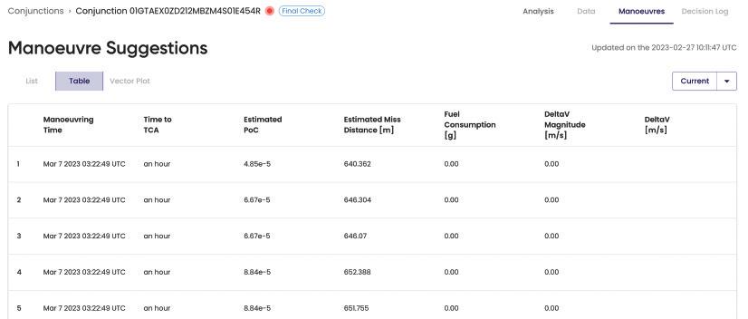
Neuraspace software screenshot - manoeuvre suggestions
Laurence Russell, Associate Editor, Satellite Evolution Group
Earth’s orbital space. The current volume of debris make collisions rare, but this isn’t particularly wise.
When it comes to best practice, an easy recommendation is a solid end-of-life plan for your satellites, rather than simply letting them drift about. This can be achieved with orbital servicing platforms capable of deorbit missions or on-board collision avoidance and maneuvering systems on the satellite which can dodge predicted collisions and perhaps even autonomously deorbit once the satellite reaches the end of its lifespan.
Satellites without maneuvering capabilities are a big liability, because even if we can track them precisely and predict a collision, there’s nothing we can do about it, because the satellite’s a sitting duck.
Another great best-practice is data sharing. Informing your orbital neighbors when and where you might be reorienting your systems. We also need to see elements in orbit passivated at end-of-life to avoid tanks or batteries exploding, which goes in-hand with stage-separation routines that don’t leave debris behind.
Of course, an especially obvious one is avoiding the temptation to blow up a satellite with a space-capable ICBM missile as a gesture of military power. Invariably, any theoretical deterrence this would achieve is undermined by the massive debris event you’d cause. It’s the exact kind of thing that could trigger a Kessler cascade effect – the theoretical scenario in which an ever-expanding network of collisions will destroy all orbital machines in an unstoppable domino effect which renders our planet’s orbital spaces inhospitable to all future launch efforts, potentially dooming our species.
The ideal solution to all this is recycling and manufacturing facilities in orbit so the orbital servicing market to come can make use of debris instead of relying solely on the graveyard orbit method in the hopes of approaching an orbital circular economy. It’s still quite Utopian of course, but I believe it can be done with the right planning today.
Question: Neuraspace describes itself as Europe’s first AI-based space traffic management system. Could you outline its features?
Chiara Manfletti: Neuraspace’s key assets in this market are AI and data fusion, which we started with from day one. One of the biggest problems with space debris is its location and tracking, made more difficult by cosmic events and space weather which is always in flux. The propagation has so many perturbations in it.
The two solutions are constant precision tracking and on-board navigation receivers that self-track the asset. That information adds up very quickly and requires
powerful data models to process everything into a clear picture with actionable conclusions.
We use AI and machine learning (ML) to classify conjunctions according to the risk that they pose to satellite operators who don’t necessarily know the exact location of their satellite, nor the minute-to-minute threats posed to it. Our algorithms also have the ingenuity to predict the uncertainty of objects over time as orbits degrade and conditions change. By being able to recognize a timeline of risk, we give our clients assurances tomorrow, and on into the future, not just today. This ingenuity alleviates effort, time, money, and market stress by giving people answers and solutions.

Question: Space is a very risky environment to operate in commercially. Is accurate debris tracking and collision avoidance capable of stabilizing the space insurance market, to better ensure investment security?
Chiara Manfletti: I think it definitely is. The insurance groups I’ve spoken to have encountered obvious difficulties in pricing premiums for space technologies, chiefly when determining the risks of operating in such an uncertain and dangerous environment.
These days collision variables are a tiny factor compared to the threat of launch failure and complications when placing a satellite into orbit. Although I have heard from some insurance experts that if the market only sees more and more risk as orbital sustainability continues to degrade, insuring satellites may cease to be economically viable for brokers. Being able to recognize risks and mitigate them, while participating in the work of clearing debris, can create the assurance needed for insurance firms to continue operating here and granting the stability of investment security.
Question: On a wider scale, what changes do we need to see from global governments, business concern groups, or corporate culture to ensure our orbital environment is sustainable for future generations?
Chiara Manfletti: The first vital step is that the problem needs to be taken seriously. I find that it’s human nature to deal with the problems that arise in front of us, rather than overthink the problems of tomorrow. Distressingly few of the important outlooks today are future minded.
When thinking about orbital sustainability we can’t limit ourselves just to stabilizing the current situation, we have to have our end-goal in mind – just as I was alluding to when I spoke about the potential of orbital recycling.
To that end, anyone can tell that using graveyard orbits as mitigation methods won’t be sustainable for the whole of the 21st century. Satellites and space vehicles make use
www.satellite-evolution.com | June 2023 30
#Space #Debris #Data Q&A Neuraspace
Neuraspace software screenshot - AI based conjunction classification
of chemicals and compounds that we can’t just keep burning into particulate in the atmosphere. There’s a better way that’s not yet viable, but that doesn’t mean we should give up striving toward best-case outcomes.
Space is so expensive, that efficiency needs to be in our DNA up there. That means sustainability needs to be a big priority whenever we plan our future in orbit. Fundamentally, a lot of this will require regulative oversight, although this will require an economically positive architecture that isn’t interpreted as a burden to businesses and investors, because we need this market to grow if we want it to improve. A great example would be allowing companies with strong sustainability plans to jump the queue in their licensing process, bringing them to market faster, and so incentivizing their good work without the need of expensive incentives or problematic disincentives.
As we see space operations transition from institutional to commercial hands, we have to see the role of public sector entities evolve in step to support the evolution while ensuring sustainability isn’t ignored in favor of short-term gains.
This work has been slower than many of us would have liked to see. The commercial sector in space has grown faster than many in global governments had predicted, and so there’s plenty of work to be done in structuring this new reality.
Many governments are still struggling with the role of becoming anchor tenants for developing space companies, which has worked for so many NewSpace success stories in the past. There are many places where we could all be improving.
Question: Experts often suggest proper space regulation will take collaboration between geopolitically opposed states. Are economic assurances enough to convince governments to the negotiating table? How can we de-
escalate space data’s fatal relevance to national defense?
Chiara Manfletti: When I was President of the Portuguese Space agency, I told the then Defense Minister of Portugal that we need less hot heads in the topic of space, even in defense to ensure we can avoid irrational escalation.
Unfortunately, much of this comes down to the people such conversations fall upon. Of course, space is very important aspect of our sovereignty, but we can’t let it turn into a shooting range because of overemotional territorial anxieties.
We’ve seen economies become key pillars of global tensions, and even weapons of war. This may not be enough of a concern to ensure level heads, but it’s certainly an incentive to drag people to the negotiating table.
We’re seeing a trend of economic autonomy creeping into the discussion, to ensure we can weather supply shortages and instability in global markets better, although not as much in the way of sharing the risk between close allies and trading partners, to ensure lifelines to our most trusted neighbors in the event of disaster. Economists agree that the most profitable outcomes are borne out of equal partners enjoying stable systems, especially when they can address one another’s shortcomings. I think we need to see a lot more conversations like that.
Question: The proposed orbital servicing economy will run on good traffic management. What’s your impression of that future market?
Chiara Manfletti: I certainly believe in the orbital servicing market. If I didn’t, I wouldn’t have joined Neuraspace and taken part in the work to establish it. We’ve seen orbital servicing establish itself in recent years across demonstrations to extend satellite life both from agencies such as the European Space Agency, but also smaller disruptive companies like Astroscale.
There’s some scepticism around its future when satellites are getting cheaper to the extent that it’s more cost-efficient to replace them than to service them, but that discounts deorbiting services. As the satellites we see in orbit diversify, so will their needs in the servicing market.
However, this economy turns out, I don’t think it’ll look like what people are theorizing today, because that’s just never the case with emergent, disruptive technology. But we can absolutely expect it to evolve. Space is critical infrastructure. It’s not just a way of delivering incredible new applications, it’s become a core part of our communications.
That said, I believe asteroid mining won’t be a part of all this. The economics of bringing resources back down to Earth from deep space is a fanciful novelty, but it just doesn’t add up. Our first steps toward true industry in space ought to be careful and sustainable ones, which means building what we create in space in the interest of using it in space. That’s the vision for which Neuraspace is creating the foundation.
www.satellite-evolution.com | June 2023 31 Q&A Neuraspace #NASA #Asia #Debris
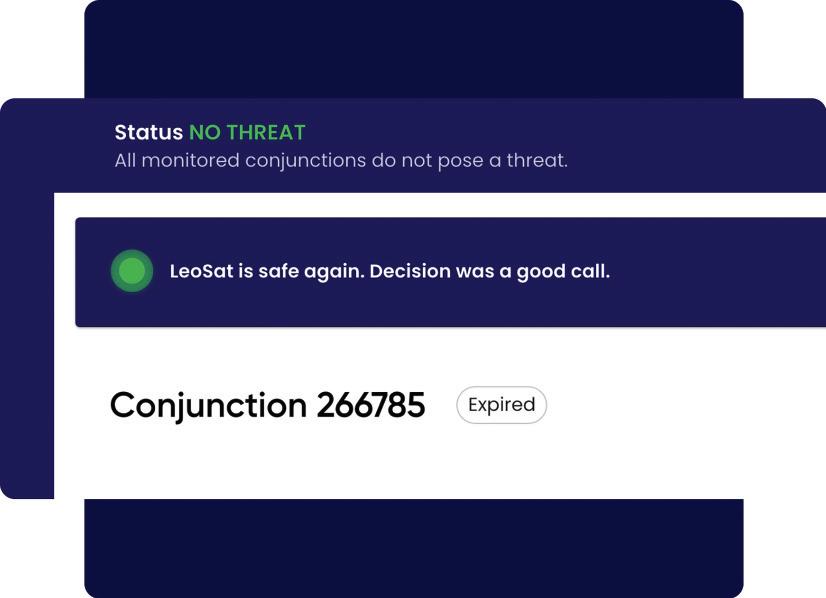
Neuraspace software screenshot - No threat response
“If orbits are being polluted, then we definitely need to learn to clean them up. This is where some of our planet’s critical infrastructure is operating after all. We’d lose more than just GPS if it all stopped working one day.”
Steve Collar, CEO, SES to step down at end of June
SES has announced that Steve Collar, Chief Executive Officer (CEO), will be stepping down at the end of June 2023 to pursue other professional and personal endeavours. The search for a successor is underway and Ruy Pinto, currently Chief Technology Officer of SES, will assume the role of CEO until a permanent successor is announced.
Frank Esser, Chairman of the SES Board of Directors, said, “We would like to thank Steve for his significant contribution to SES over a period of more than 20 years. As CEO, Steve successfully steered SES, leaving the business in a strong position for the future with a differentiated multi-orbit capability, world-class set of customer solutions, a simplified and market-centric organisation, and a strong balance sheet set to be further strengthened from the execution of C-band clearing. The current market environment is rapidly changing, and I welcome Ruy Pinto, who leads over half of the SES workforce today and has substantial industry experience, as we address the challenges and capture further opportunities in the market. The Board has full confidence in Ruy and our management’s engagement on continued strong execution as we embark on a new phase of success for SES.”
Steve Collar commented, “It has been the greatest honour of my life to lead the incredible people at SES. SES has been the benchmark in the industry for decades and I leave the company as its leader and go back to being a huge supporter, admirer and fan and will be cheering Ruy and the Management Team on from the side-lines. With O3b mPOWER launching, the company performing well and C-band all but delivered, the future is bright, and I wish the Board and everyone at SES every success.”
Ruy Pinto joined SES in February 2017 and was appointed Chief Technology Officer in January 2019, driving the differentiation in multi-orbit capabilities and the cloudification of SES. Prior to SES,
Ruy spent over 25 years at Inmarsat in various lead technical and managerial roles.
Ruy Pinto commented, “I am delighted to be leading SES and working with our teams around the world through a transition period, progressing SES into a phase where we will continue to grow on a strong value creation trajectory for our stakeholders, executing strongly, simplifying our business and optimizing our cost base.”
AsiaSat announces appointment of Raymond Chow as Chief Commercial Officer
Asia Satellite Telecommunications announced that Raymond Chow has been appointed as the Chief Commercial Officer.
Joining AsiaSat in 2018, Raymond most recently served as Vice President, Business Development and Strategy, responsible for growing the data business and the transformation of AsiaSat. In his new role, Raymond will lead and execute the global commercial strategies for AsiaSat and its subsidiaries/associated brands including sales, marketing, solutions as well as new product development to meet ever-changing customer requirements.
“It is my pleasure to announce the appointment of Raymond Chow as Chief Commercial Officer. Raymond is a seasoned executive with demonstrated accomplishments within AsiaSat. His broad expertise in satellite communications and international markets will be the most valuable in driving business growth and facilitating the synergy of data and media services as we continue to expand our endto-end solution offerings to customers,” said Roger Tong, Chief Executive Officer of AsiaSat.
“I am excited by this opportunity to lead our commercial, marketing and business development efforts to realize synergies and build partnerships for our business growth. I look forward to continuing to work closely with the team and other business units and departments of AsiaSat to develop products and solutions that meet customer needs,” said Raymond Chow, Chief Commercial Officer of AsiaSat.
www.satellite-evolution.com | June 2023 32 #SES #AsiaSat #SteveCollar #RaymondChow
Executive Movers & Shakers
Steve Collar, CEO, SES

Bengt Jonsson appointed Forsway Chairman
Forsway has announced that Board member Bengt Jonsson has been appointed as the technology company’s Chairman. Bengt joined the Forsway Board of Directors in January 2021, and takes over from Mats Andersson, who served as Chairman from May 2014 – May 2023. Andersson continues to support Forsway as a member of the Board.
“An excellent candidate to take the helm, we are very pleased Bengt has signed on as Chairman,” says Tobias Forsell, CEO, Forsway. Already a Board member, his extensive network and background from emerging markets and executive level positions in the global technology arena have already proven to be a valuable asset to our long-term goals and growth objectives.”
“We thank our outgoing Chairman, Mats Andersson, for his strong leadership, and extend our gratitude for the thought-leading vision and extensive guidance he has provided Forsway in our journey together in the past 9 years. A highly inspirational leader, I am pleased that he will continue to support Forsway as a Board member.”
A long-time investor with strong roots in Forsway, Bengt previously served as Managing Director and brings extensive insight and experience to the Chairmanship.
“I am pleased to embark on this next step in developing Forsway’s global growth journey with my fellow Board members and a highly engaged management team,” says Bengt Jonsson. The company’s vision to enable broadband services and connectivity for the hundreds of millions lacking internet access around the globe is a goal that can make the world a truly better place - providing opportunities for prosperity, education, and health services.”

www.satellite-evolution.com | June 2023 34
Movers & Shakers
Executive
Bengt Jonsson appointed Forsway Chairman